Pra Loup - Barcelonnette
Pra Loup
| Pra-Loup | |
|---|---|

Pra-Loup
|
|
| Location | Uvernet-Fours, Alpes-de-Haute-Provence , France |
| Nearest city | Barcelonnette, France |
| Coordinates | 44.369°N 6.601°ECoordinates: 44.369°N 6.601°E |
| Vertical | 1,000 m (3,280 ft) |
| Top elevation | 2,500 m (8,200 ft) |
| Base elevation | 1,500 m (4,920 ft) |
| Runs |
39 |
| Total length | 180 km (110 mi) |
| Website | www |


Pra-Loup is a ski resort in France, at Uvernet-Fours in the Alpes-de-Haute-Provence, 7 km (4 mi) from the town of Barcelonnette.
Tour de France
Pra-Loup was used as the finish of stage 15 in the 1975 Tour de France. The 217 km (135 mi) race from Nice was won by Bernard Thévenet of France, and is regarded in cycling lore as the mountain climb where the career of Eddy Merckx faltered.[3] (See Eddy Merckx - 1975 Tour de France, Pierre Chany). The French magazine Vélo called him "the most accomplished rider that cycling has ever known."[4] The American publication, VeloNews, called him the greatest and most successful cyclist of all time.[5] The climb is cemented into the history of French cycling by the image of a woman at the roadside, wearing a bikini, waving a sign that said: "Merckx is beaten. The Bastille has fallen."[6]
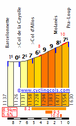
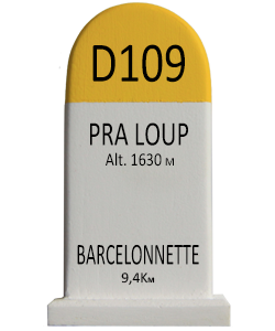
- Elevation - 1,630 m (5,350 ft)
- Departure: Barcelonnette - 1,130 m (3,710 ft)
- Vertical rise: 500 m (1,640 ft)
- Length: 9.4 km (5.8 mi)
- Slope: 5.3% of average (maximum 10.1%)