xYour article is added to your cart Click here to go immediately to your cart.
Click here if you want an engraved road marker (+ 7€)
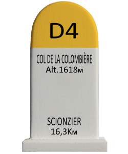
Col de la Colombière (elevation 1613 m) is a mountain pass in the Alps in the department of Haute-Savoie in France.
It connects Cluses in the Arve valley with Le Grand-Bornand in the Borne valley. The road then leads further to Annecy or over Col des Aravis to the Arly valley and is situated between the Massif des Bornes to the north-west and the Chaîne des Aravis to the south-east.
The pass is not an important traffic route because there are better roads that parallel it, particularly the A40 autoroute.
Although the pass is not very high, it is technically difficult for cyclists.[citation needed]
Starting from Scionzier, the climb is 16.3 km long. Over this distance, the climb is 1108 m (an average percentage of 6.8%). The steepest section is 10.2% near the summit. From Le Grand-Bornand, the Col de la Colombière is 11.7 km long. Over this distance, the climb is 690 m (an average percentage of 5.9%).[citation needed]
On May 31, 2015, U.S. Secretary of State John Kerry broke his leg near the start of the climb in Scionzier.[1]
The pass was first included in the Tour de France in 1960 and has since featured 20 times, most recently in 2010.[2]
9 €
…